|
ABOUT
INDIA
 |
Places
of interest in India |
|
India
Gate, New Delhi: An impressive example of colonial
architecture, India Gate is a symbol of modern Delhi.
The 138 ft / 42 m high stone arch was built by the British
in honor of Indian soldiers killed in World War I. A permanent
flame honors Indian soldiers who died in wars since 1918.
A popular tourist attraction, the gate is also a gathering
place for Delhi residents, who love to stroll the area
at night, eating ice cream and buying strands of flowers.
Qutub
Minar, New Delhi: One of the most visited tourist
spot of Delhi, Qutub Minar was built in 1199 by Qutub-ud-Din.
The sultan's successor and son-in-law, Iltutmish, completed
it. The purpose of building this beautiful monument is
not very clear as some believe that it was built as a
tower of victory to signify the beginning of the Muslim
rule in India, while others say it served as a minaret
to the adjoining mosque and was used by the muezzins to
call the faithful to prayer. It is 72.5 metres high and
one has to climb 379 steps to get to the top. The diameter
of the base is 14.3 metres while the top flor measures
2.7 metres in diameter.
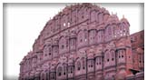
Hawa
Mahal, Jaipur (Rajasthan): Built in 1799, the
Hawa Mahal, or the Palace of the Winds, is one of the
major landmarks of Jaipur, The Pink City. This five-storey
building, which looks out over the main street of the
old city, is a stunning exmple of Rajput artistry, with
its pink semioctagonal and delicately honeycombed sandstone
windows. It was originally built to enable ladies of the
royal household to watch the everyday life of the city.
The palace was built by Maharaja Sawai Pratap Singh, and
is part of the City Palace.
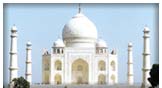
Taj
Mahal, Agra: A white marble tomb built in 1631-48
in Agra, by Emperor Shah Jehan for his wife, Arjuman Banu
Begum, is one of the Seven Wonders of the World and is
the symbol of true love. The Taj Mahal sums up many of
the formal themes that have played through Islamic architecture.
Its refined elegance is a conspicuous contrast both to
the Hindu architecture of pre-Islamic India, with its
thick walls, carved arches, heavy lintels in the Indo-Islamic
styles, in which Hindu elements are combined with an eclectic
assortment of motifs from Persian and Turkish sources.
|
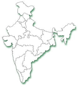
| Geography |


|
|
Location
|
:
|
Southern
Asia, bordering the Arabian Sea and the Bay of Bengal,
between Burma and Pakistan
Map references: Asia
|
|
Area
|
:
|
Total:
3,287,590 sq km
|
|
Land
|
:
|
2,973,190
sq km
|
|
Water
|
:
|
314,400
sq km
|
|
|
|
|
|
Area
- comparative
|
:
|
Slightly
more than one-third the size of the US
|
|
Land
boundaries
|
:
|
Total:
14,103 km
|
|
Border
countries
|
:
|
Bangladesh
4,053 km, Bhutan 605 km, Burma 1,463 km, China 3,380 km,
Nepal 1,690 km, Pakistan 2,912 km
|
|
Climate
|
:
|
Varies
from tropical monsoon in south to temperate in north
|
|
Terrain
|
:
|
Upland
plain (Deccan Plateau) in south, flat to rolling plain
along the Ganges, deserts in west, Himalayas in north
|
|
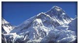
Elevation
extremes
|
:
|
lowest
point: Indian Ocean 0 m
highest point: Kanchenjunga 8,598 m
|
|
Natural
resources
|
:
|
Coal
(fourth-largest reserves in the world), iron ore, manganese,
mica, bauxite, titanium ore, chromite, natural gas, diamonds,
petroleum, limestone, arable land
|
|
Irrigated
land
|
:
|
590,000
sq km (1998 est.)
|
|
|
|
|
|
People
|
|
Population
|
:
|
1
Billion
(1,045,845,226 (July 2002 est.)
|
|
Religions
|
:
|
Hindu
81.3%, Muslim 12%, Christian 2.3%, Sikh 1.9%, other groups
including Buddhist, Jain, Parsi 2.5% (2000)
|
|
Languages
|
:
|
English
enjoys associate status but is the most important language
for national, political, and commercial communication;
Hindi is the national language and primary tongue of 30%
of the people; there are 14 other official languages:
Bengali, Telugu, Marathi, Tamil, Urdu, Gujarati, Malayalam,
Kannada, Oriya, Punjabi, Assamese, Kashmiri, Sindhi, and
Sanskrit; Hindustani is a popular variant of Hindi/Urdu
spoken widely throughout northern India but is not an
official language
|
|
Literacy
|
:
|
Definition:
age 15 and over can read and write
Total Population: 52%
Male: 65.5%
Female: 37.7% (1995 est.)
|
|
|
|
|
|
Government
|
|
Government
type
|
:
|
Federal
Republic
|
|
Capital
|
:
|
New
Delhi
|
|
Administrative
Divisions
|
:
|
28
states and 7 union territories*; Andaman and Nicobar Islands*,
Andhra Pradesh, Arunachal Pradesh, Assam, Bihar, Chandigarh*,
Chhattisgarh, Dadra and Nagar Haveli*, Daman and Diu*,
Delhi*, Goa, Gujarat, Haryana, Himachal Pradesh, Jammu
and Kashmir, Jharkhand, Karnataka, Kerala, Lakshadweep*,
Madhya Pradesh, Maharashtra, Manipur, Meghalaya, Mizoram,
Nagaland, Orissa, Pondicherry*, Punjab, Rajasthan, Sikkim,
Tamil Nadu, Tripura, Uttaranchal, Uttar Pradesh, West
Bengal
|
|
Independence
|
:
|
15
August 1947 (from UK)
|
|
Constitution
|
:
|
26
January 1950
|
|
Legal
system
|
:
|
based
on English common law; limited judicial review of legislative
acts; accepts compulsory ICJ jurisdiction, with reservations
|
|
Economy
- overview
|
:
|
India's
economy encompasses traditional village farming, modern
agriculture, handicrafts, a wide range of modern industries,
and a multitude of support services. Overpopulation severely
handicaps the economy. Government controls have been reduced
on imports and foreign investment, and privatization of
domestic output has proceeded slowly. The economy has
posted an excellent average growth rate of 6% since 1990,
reducing poverty by about 10 percentage points. India
has large numbers of well-educated people skilled in the
English language; India is a major exporter of software
services and software workers.
|
|
GDP
|
:
|
Purchasing
power parity - $2.66 trillion (2002 est.)
|
|
GDP
- real growth rate
|
:
|
4%
(2002 est.)
|
|
GDP
- per capita
|
:
|
Purchasing
power parity - $2,540 (2002 est.)
|
|
GDP
- composition
|
:
|
By
sector:
Agriculture: 25%
Industry: 25%
Services: 50% (2002 est.)
|
|
Electricity
- production
|
:
|
547.12
billion kWh (FY 2000-01, utilities only) (2000)
|
|
Exports
|
:
|
$44.5
billion (f.o.b., 2001)
|
|
Exports
- commodities
|
:
|
Textile
goods, Handicrafts, Gems and Jewelry, Engineering goods,
Chemicals, Leather finished goods
|
|
Exports
- partners
|
:
|
US
22.8%, Hong Kong 5.8%, Japan 5.3%, UK 5.3%, Germany 4.6%
(2000)
|
|
|
|
|
|
Transportation
|
|
Railways
|
:
|
Total:
63,693 km (13,771 km electrified)
|
|
Highways
|
:
|
Total:
3,319,644 km
Paved: 1,517,077 km
Unpaved: 1,802,567 km (1996)
|
|
Waterways
|
:
|
16,180
km
note: 3,631 km navigable by large vessels
|
|
Ports
and harbors
|
:
|
Chennai
(Madras), Cochin, Jawaharal Nehru, Kandla, Kolkata (Calcutta),
Mumbai (Bombay), Vishakhapatnam
|
|
Airports
|
:
|
335
(2001)
234 with paved runways
|
|
|
|
|
|
Internet
country code
|
:
|
.in
|
|
Download
Map [PDF] 
|
|
|